| # | sample_id | image_bytes | caption | layer | scale | img_w | lang | building_frac | bbox | metadata |
|---|
1
|
tile_000095_05
|
|
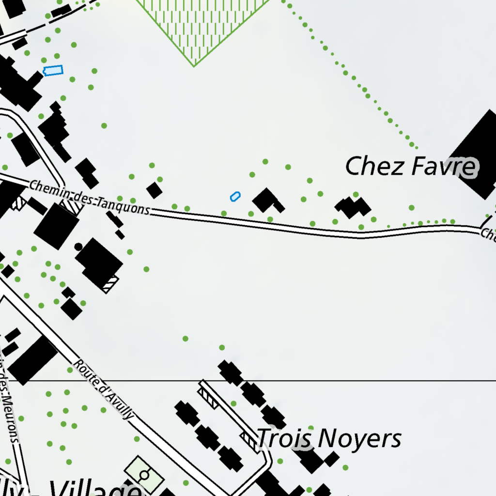
A network of roads and scattered buildings defines this area. In the upper left, a cluster of black rectangular buildings is arranged along a road that curves from the top edge downward. A blue outline of a small structure sits just east of this cluster. Further south, the road continues as Chemin des Tanquons, running horizontally across the center of the map. Along this road, several black buildings are spaced apart, with one larger complex on the left and several smaller ones to the right. To the east of Chemin des Tanquons, the text "Chez Favre" is positioned above a group of three black buildings.

In the lower portion of the map, Route d'Avully runs diagonally from the center-left toward the bottom right. This road intersects with another path coming from the left, labeled "les Meurons." Along Route d'Avully, a series of black rectangular structures are aligned linearly, leading toward the text "Trois Noyers." Below this, another road curves toward the bottom left, passing by the text "Village."

Green dots are scattered throughout the landscape, with a higher concentration in the upper left and lower left areas. In the top center, a triangular area is filled with green vertical stripes. A dotted green line curves from the top center toward the right edge of the map. Small blue outlines of structures are sparsely placed, one in the upper left and another near the center.
|
ch.swisstopo.pixelkarte-farbe
|
0.75
|
1024
|
it
|
0.19434
|
2489065.08,1113912.78,2489440.08,1114287.78
|
{"sample_id": "tile_000095_05", "tile_id": "tile_000095", "bbox": "2489065.08,1113912.78,2489440.08,1114287.78", "layer": "ch.swisstopo.pixelkarte-farbe", "img_w": 1024, "img_h": 1024, "lang": "it", "scale": 0.75, "building_frac": 0.19434, "url": "https://wms.geo.admin.ch/?SERVICE=WMS&VERSION=1.3.0&REQUEST=GetMap&LAYERS=ch.swisstopo.pixelkarte-farbe&STYLES=&FORMAT=image%2Fpng&CRS=EPSG%3A2056&BBOX=2489065.08%2C1113912.78%2C2489440.08%2C1114287.78&WIDTH=1024&HEIGHT=1024&TRANSPARENT=false&LANG=it", "key": "000000117", "status": "success", "error_message": null, "width": 1024, "height": 1024, "original_width": 1024, "original_height": 1024, "exif": "{}", "sha256": "ad4b45d75ac25ff85787799e08f216999df497e46521e036a6c2580bec8914aa", "shard": 0}
|
2
|
tile_000095_06
|
|
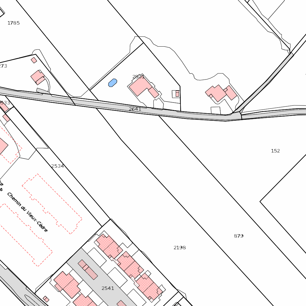
A network of black boundary lines divides the landscape into irregularly shaped parcels of land. A primary road runs horizontally across the center, curving slightly as it moves from west to east, with the number 2641 printed along its path. To the north of this road, several small, light-pink rectangular structures are clustered, including one labeled 2801 and another nearby with a small blue oval shape adjacent to it. These structures are enclosed within their own smaller boundary lines. Further north, a larger, open parcel is marked with the number 1785.

South of the main road, the land is divided by long, diagonal boundary lines sloping from the northwest to the southeast. A large open area is marked with the number 152 on the right and 879 toward the bottom center. To the west, a dashed red line outlines a rectangular area, and a label reads "Chemin du Vieux-Cèdre" along a path that runs diagonally. In the bottom left and center, a denser cluster of light-pink rectangular buildings is arranged in a row, with the number 2541 placed among them. These buildings are connected by a gray-shaded area that suggests a paved surface or driveway. A smaller road or path curves from the bottom left corner toward the center, intersecting with the boundary lines of the residential cluster. Other parcel numbers, such as 2534 and 2198, are scattered across the open white spaces between the boundaries.
|
ch.kantone.cadastralwebmap-farbe
|
0.5
|
1024
|
en
|
0.19434
|
2489151.02,1113956.76,2489401.02,1114206.76
|
{"sample_id": "tile_000095_06", "tile_id": "tile_000095", "bbox": "2489151.02,1113956.76,2489401.02,1114206.76", "layer": "ch.kantone.cadastralwebmap-farbe", "img_w": 1024, "img_h": 1024, "lang": "en", "scale": 0.5, "building_frac": 0.19434, "url": "https://wms.geo.admin.ch/?SERVICE=WMS&VERSION=1.3.0&REQUEST=GetMap&LAYERS=ch.kantone.cadastralwebmap-farbe&STYLES=&FORMAT=image%2Fpng&CRS=EPSG%3A2056&BBOX=2489151.02%2C1113956.76%2C2489401.02%2C1114206.76&WIDTH=1024&HEIGHT=1024&TRANSPARENT=false&LANG=en", "key": "000000118", "status": "success", "error_message": null, "width": 1024, "height": 1024, "original_width": 1024, "original_height": 1024, "exif": "{}", "sha256": "1d56777c3705429ed278f082b693a4bb3b8ca6bbd18440d3cc334ed79ac3e2f7", "shard": 0}
|
3
|
tile_000111_00
|
|
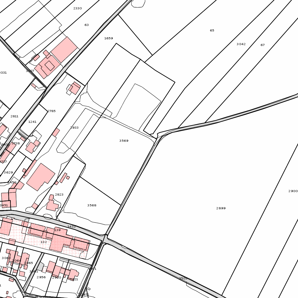
A network of black boundary lines divides the landscape into irregular polygons of varying sizes and shapes. In the upper right and central right areas, large, elongated parcels dominate, including plot 65, plot 3042, plot 67, and the expansive plot 2899. These large areas are separated by long, straight diagonal lines that run from the upper left toward the lower right.

In the upper left and central left sections, the land is divided into much smaller, more complex plots. Several of these smaller areas are highlighted in light pink, indicating built-up structures or specific land uses. These pink shapes are clustered primarily along a road or path that winds from the top left toward the center. Plot 2330 is located at the very top, with plot 63 and plot 1659 situated just below it. Further down and to the left, a cluster of pink buildings surrounds plot 2811 and plot 1241.

A prominent road or boundary line cuts diagonally across the lower half of the image, separating plot 3568 and plot 3569 from the large plot 2899 to the east. To the left of this diagonal line, there is a dense concentration of small, pink-shaded rectangular plots, including those labeled 132 and 139. These are interspersed with smaller white parcels such as 2823 and 3437. In the bottom left corner, further small plots are identified by numbers such as 3003, 2956, and 2920, with additional pink structures clustered tightly together.

The overall layout shows a transition from a densely developed area with many small, interconnected plots and buildings on the left to a more open landscape with large, expansive fields on the right. The boundary lines create a web of intersections, with some roads running parallel to the diagonal axis and others cutting across it perpendicularly.
|
ch.kantone.cadastralwebmap-farbe
|
0.75
|
1024
|
en
|
0.11328
|
2489445.73,1112377.88,2489820.73,1112752.88
|
{"sample_id": "tile_000111_00", "tile_id": "tile_000111", "bbox": "2489445.73,1112377.88,2489820.73,1112752.88", "layer": "ch.kantone.cadastralwebmap-farbe", "img_w": 1024, "img_h": 1024, "lang": "en", "scale": 0.75, "building_frac": 0.11328, "url": "https://wms.geo.admin.ch/?SERVICE=WMS&VERSION=1.3.0&REQUEST=GetMap&LAYERS=ch.kantone.cadastralwebmap-farbe&STYLES=&FORMAT=image%2Fpng&CRS=EPSG%3A2056&BBOX=2489445.73%2C1112377.88%2C2489820.73%2C1112752.88&WIDTH=1024&HEIGHT=1024&TRANSPARENT=false&LANG=en", "key": "000000096", "status": "success", "error_message": null, "width": 1024, "height": 1024, "original_width": 1024, "original_height": 1024, "exif": "{}", "sha256": "8c82e525bf9579fa33e4d16cf46f94e7ee3e37fc088eff1ecaf29a9b5841f763", "shard": 0}
|
4
|
tile_000117_06
|
|
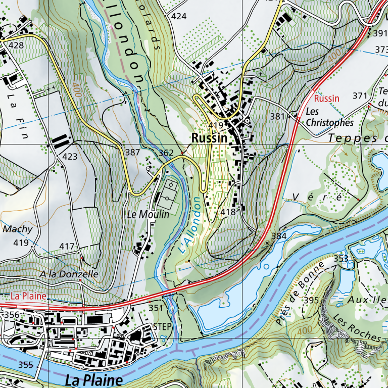
The village of Russin occupies a central position, situated on a slope above the Allondon river valley. The settlement is clustered around a network of small roads and paths, with buildings concentrated primarily between the 419 and 418 elevation markers. To the south of the main village center lies the hamlet of Le Moulin, connected to Russin by a winding road that follows the contour of the hill.

The Allondon river flows from the northwest to the southeast, carving a valley through the landscape. Its course is flanked by green, wooded areas and slopes that rise toward the northwest. A blue line tracks the river's path, passing between Le Moulin and the main body of Russin. Further south, the Allondon joins a larger body of water, which flows eastward, bordering the area known as Prés de Bonne.

A primary road, marked with a red and yellow line, runs north-to-south along the eastern edge of the Russin settlement, curving southeastward to cross the river near the 384 elevation marker. This road connects the village to the region of Les Christophes to the northeast and leads toward La Plaine to the southwest.

In the southwestern corner, the settlement of La Plaine is situated on lower ground, characterized by a denser grid of buildings and roads. A wastewater treatment plant (STEP) is located on the edge of La Plaine, positioned between the residential area and the riverbank.

The terrain is marked by varying elevations, with the highest points appearing in the northwest near the 428 and 424 markers and the lowest points along the riverbeds. Contour lines indicate steep slopes descending from the plateau of Russin and the hills of La Fin toward the valley floor. To the east, the land levels out slightly toward Teppes, while the southeastern area features the undulating terrain of Les Roches.
|
ch.swisstopo.pixelkarte-farbe
|
4.0
|
768
|
en
|
0.01489
|
2488750.61,1114743.96,2490750.61,1116743.96
|
{"sample_id": "tile_000117_06", "tile_id": "tile_000117", "bbox": "2488750.61,1114743.96,2490750.61,1116743.96", "layer": "ch.swisstopo.pixelkarte-farbe", "img_w": 768, "img_h": 768, "lang": "en", "scale": 4.0, "building_frac": 0.01489, "url": "https://wms.geo.admin.ch/?SERVICE=WMS&VERSION=1.3.0&REQUEST=GetMap&LAYERS=ch.swisstopo.pixelkarte-farbe&STYLES=&FORMAT=image%2Fpng&CRS=EPSG%3A2056&BBOX=2488750.61%2C1114743.96%2C2490750.61%2C1116743.96&WIDTH=768&HEIGHT=768&TRANSPARENT=false&LANG=en", "key": "000000070", "status": "success", "error_message": null, "width": 768, "height": 768, "original_width": 768, "original_height": 768, "exif": "{}", "sha256": "b7f29b320b86b5d7e165dade52cf3859d05fa6ac7b98d5630b063e5f485d777f", "shard": 0}
|
5
|
tile_000107_06
|
|
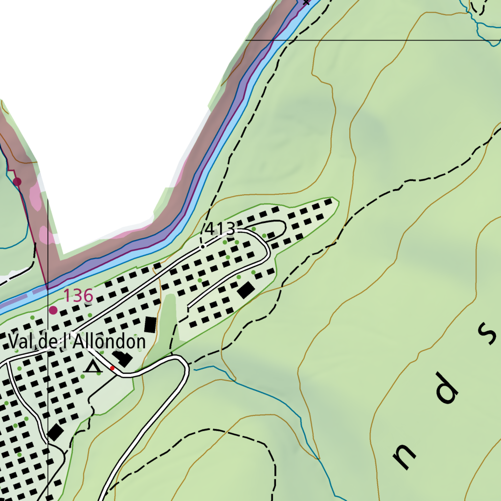
A residential settlement named Val de l'Allondon is situated in a valley, bounded by a river to the northwest and rising terrain to the east and south. The settlement is characterized by a dense cluster of small black rectangles representing buildings, arranged along a network of winding white roads. These roads branch off a main artery that runs generally east-west through the center of the village.

To the northwest, a river flows in a southeasterly direction, marked by a blue line flanked by light blue and pinkish-grey shaded areas. A road follows the river's edge, separated from the water by a thin strip of land. The number 136 is placed near this road on the western edge of the village.

The village layout is irregular, with buildings clustered more tightly in the western and central sections and becoming more sparse toward the east. A loop road extends eastward, curving around a small green area before returning toward the center. The number 413 is located near this eastern loop.

To the east and south, the terrain rises, indicated by brown contour lines. A dashed black line, likely representing a trail or boundary, winds up the hillside from the eastern edge of the village, heading northeast. Another dashed line runs along the southern perimeter of the settlement. A thin blue stream flows southward from the hills, crossing the southern edge of the village. The words "nd s" are visible in large black letters across the green hillside in the southeast.
|
ch.swisstopo.pixelkarte-farbe
|
1.0
|
1024
|
fr
|
0.01001
|
2488952.33,1119540.12,2489452.33,1120040.12
|
{"sample_id": "tile_000107_06", "tile_id": "tile_000107", "bbox": "2488952.33,1119540.12,2489452.33,1120040.12", "layer": "ch.swisstopo.pixelkarte-farbe", "img_w": 1024, "img_h": 1024, "lang": "fr", "scale": 1.0, "building_frac": 0.01001, "url": "https://wms.geo.admin.ch/?SERVICE=WMS&VERSION=1.3.0&REQUEST=GetMap&LAYERS=ch.swisstopo.pixelkarte-farbe&STYLES=&FORMAT=image%2Fpng&CRS=EPSG%3A2056&BBOX=2488952.33%2C1119540.12%2C2489452.33%2C1120040.12&WIDTH=1024&HEIGHT=1024&TRANSPARENT=false&LANG=fr", "key": "000000110", "status": "success", "error_message": null, "width": 1024, "height": 1024, "original_width": 1024, "original_height": 1024, "exif": "{}", "sha256": "ed1e0222cab0167411c382f7ba872f834148568b108d915efc1b3a25ed875d5b", "shard": 0}
|
6
|
tile_000018_03
|
|
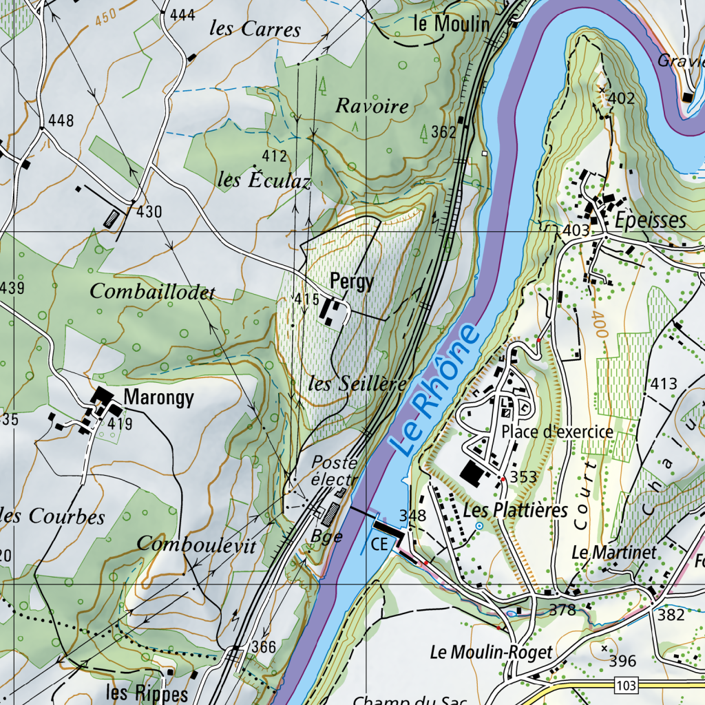
A river, Le Rhône, flows from the north toward the south, curving slightly toward the east in the upper section and then bending back toward the southwest. The river is flanked by steep, terraced hillsides on the western bank and a more varied landscape of flats and slopes on the eastern bank.

On the western side of the river, the terrain rises into a series of hills and valleys. In the north, the area of les Carres is characterized by open land and scattered elevation points, including 450 and 444. South of this lies Ravoire, with a peak at 362. Further south, the landscape dips into a valley containing les Éculaz (elevation 412) and Combaillodet, with a nearby point at 430. To the southwest, the land slopes toward Marongy (elevation 419) and les Courbes, while the area of Comboulevit occupies a lower ridge. A series of thin, winding roads connect these settlements, weaving through green spaces and across elevation contours. A railway line runs parallel to the river's western bank, cutting through the terrain from north to south.

Along the western riverbank, a "Poste électr" (electrical station) is situated near the water, and a bridge (Bge) crosses the Rhône toward the east.

On the eastern side of the river, the terrain is more fragmented. In the north, the area of Epeisses is nestled between a hill (elevation 402) and the river, with roads leading south toward a large open area labeled "Place d'exercice." This open space is bordered to the east by a wooded area and a series of paths. South of the Place d'exercice is the settlement of Les Plattières, with a peak at 353. Further south, the land levels out into the area of Le Moulin-Roget, featuring a road marked 103 and a peak at 396. The area of Le Martinet lies between Les Plattières and Le Moulin-Roget.

The eastern bank is crisscrossed by a network of small roads and paths that link the riverfront to the inland settlements of Epeisses and Le Moulin-Roget. A small tributary or stream flows from the east, passing through the "Court" area before joining the Rhône.
|
ch.swisstopo.pixelkarte-farbe
|
4.0
|
1024
|
en
|
0.01074
|
2485960.54,1112657.27,2487960.54,1114657.27
|
{"sample_id": "tile_000018_03", "tile_id": "tile_000018", "bbox": "2485960.54,1112657.27,2487960.54,1114657.27", "layer": "ch.swisstopo.pixelkarte-farbe", "img_w": 1024, "img_h": 1024, "lang": "en", "scale": 4.0, "building_frac": 0.01074, "url": "https://wms.geo.admin.ch/?SERVICE=WMS&VERSION=1.3.0&REQUEST=GetMap&LAYERS=ch.swisstopo.pixelkarte-farbe&STYLES=&FORMAT=image%2Fpng&CRS=EPSG%3A2056&BBOX=2485960.54%2C1112657.27%2C2487960.54%2C1114657.27&WIDTH=1024&HEIGHT=1024&TRANSPARENT=false&LANG=en", "key": "000000075", "status": "success", "error_message": null, "width": 1024, "height": 1024, "original_width": 1024, "original_height": 1024, "exif": "{}", "sha256": "9b8121755d2574a712bc0179d8bccd17bd1ed2516afdd6d6e11d82cedede70d3", "shard": 0}
|
7
|
tile_000018_05
|
|
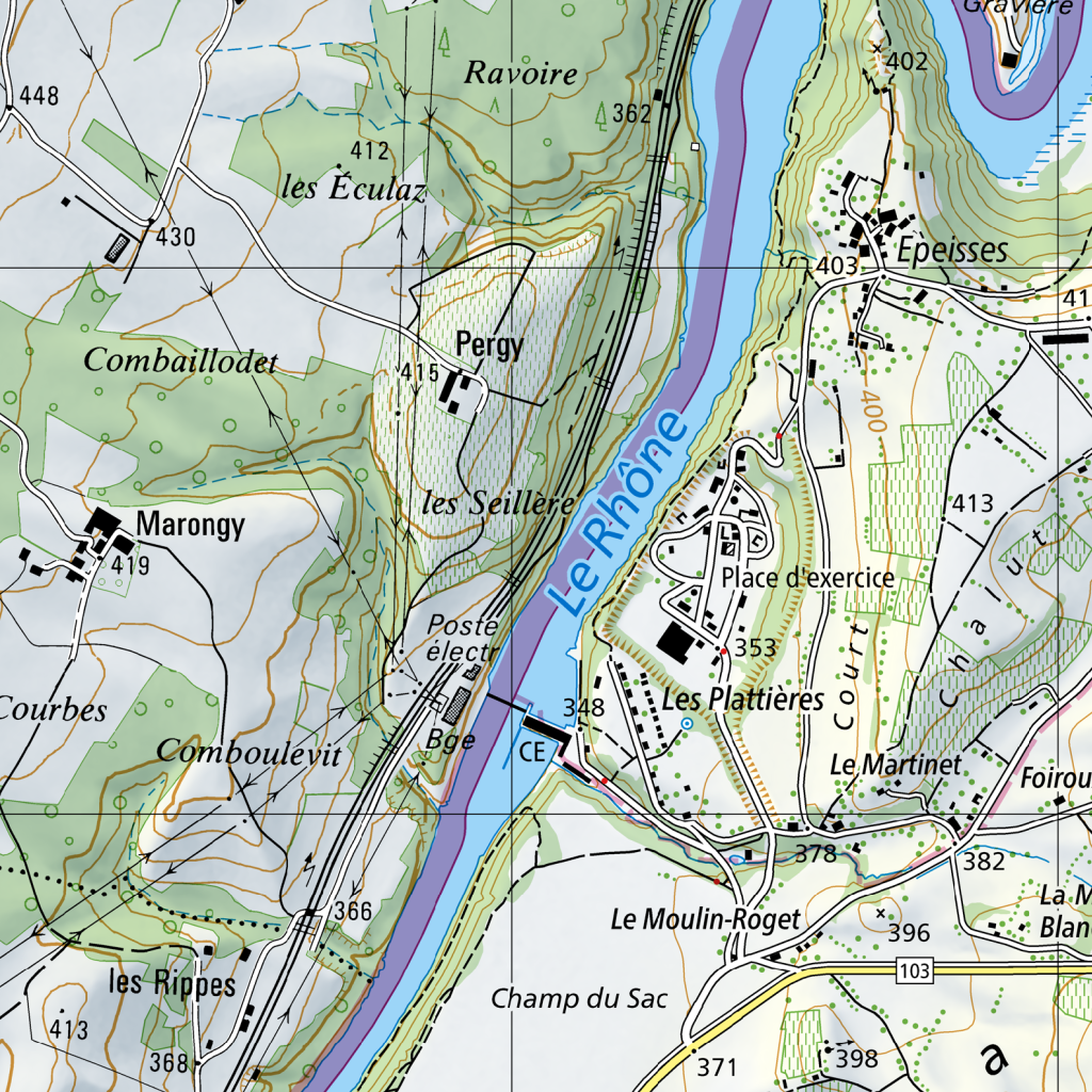
The Rhône river flows from the north towards the south, curving slightly to the west. Its banks are lined with steep, shaded terrain, particularly on the west side where the land rises sharply. Along the western bank, a railway line runs parallel to the river, cutting through the landscape from north to south.

On the west side of the river, the terrain is characterized by rolling hills and scattered settlements. In the north, the area of Ravoire is marked by elevation 362, with the hamlet of les Éculaz situated nearby at elevation 412. Further south and west, the settlement of Combaillodet sits in a valley, while Marongy is located further west at elevation 419. Between Marongy and the river lies the area of Comboulevit. The settlement of Pergy is positioned on a slope overlooking the river, with les Seillère located just south of it. Near the river's edge, the Poste électr. and the area of Boé are situated, with elevation 348 marked near the water. Further south, the area of les Rippes is noted, with elevations 366 and 368.

On the east side of the river, the settlement of Epeisses is located in the north at elevation 403. South of Epeisses, the landscape opens into a flatter area featuring a Place d'exercice and the settlement of Les Plattières at elevation 353. To the east of Les Plattières, the land rises toward the area of Le Martinet, with elevation 413 and 382 nearby. The area of Foirou is located further east. To the south, the terrain descends toward Le Moulin-Roget at elevation 378 and Champ du Sac, with elevations 396, 398, and 371. A road, marked 103, runs east-west across the southern portion of the map.

Roads connect the various settlements on both sides of the river. On the west, roads link Ravoire, les Éculaz, Pergy, and Marongy. On the east, roads connect Epeisses, Les Plattières, and Le Moulin-Roget. The railway line on the west side serves as a major north-south artery, passing through the steep terrain and near the river's edge.
|
ch.swisstopo.pixelkarte-farbe
|
4.0
|
1024
|
de
|
0.01074
|
2486062.10,1112490.61,2488062.10,1114490.61
|
{"sample_id": "tile_000018_05", "tile_id": "tile_000018", "bbox": "2486062.10,1112490.61,2488062.10,1114490.61", "layer": "ch.swisstopo.pixelkarte-farbe", "img_w": 1024, "img_h": 1024, "lang": "de", "scale": 4.0, "building_frac": 0.01074, "url": "https://wms.geo.admin.ch/?SERVICE=WMS&VERSION=1.3.0&REQUEST=GetMap&LAYERS=ch.swisstopo.pixelkarte-farbe&STYLES=&FORMAT=image%2Fpng&CRS=EPSG%3A2056&BBOX=2486062.10%2C1112490.61%2C2488062.10%2C1114490.61&WIDTH=1024&HEIGHT=1024&TRANSPARENT=false&LANG=de", "key": "000000077", "status": "success", "error_message": null, "width": 1024, "height": 1024, "original_width": 1024, "original_height": 1024, "exif": "{}", "sha256": "a6168f1090ae1f2888fcd94190b34ff9f3685d81182044f6a98123e5c98cbd67", "shard": 0}
|
8
|
tile_000098_01
|
|
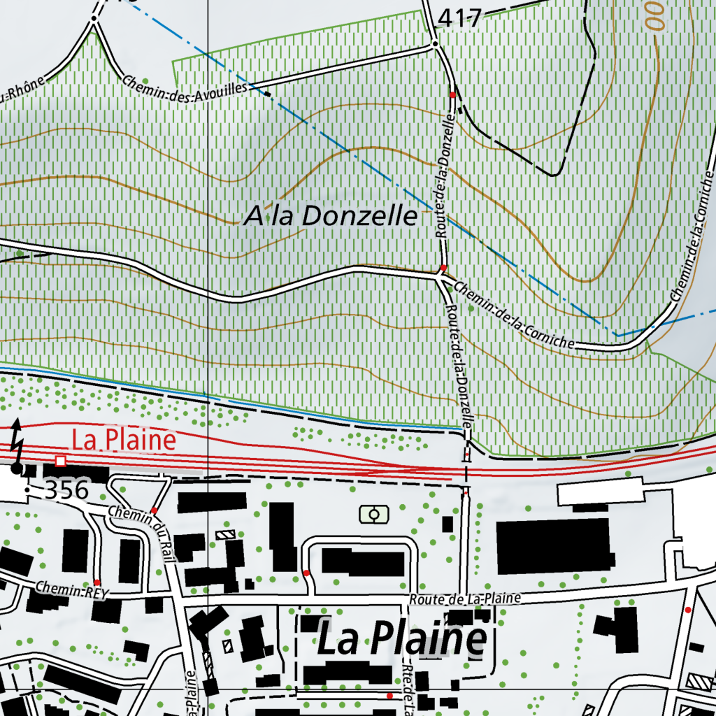
The area is divided into a hilly northern section and a more developed southern section, separated by a primary east-west corridor.

In the northern region, the terrain is marked by numerous contour lines indicating elevation. A road, Chemin des Avouilles, enters from the northwest and curves southeast. Further east, Route de la Donzelle runs vertically through the center of the map, intersecting with the area labeled "A la Donzelle." Towards the northeast, Chemin de la Corniche winds through the hills, connecting to Route de la Donzelle.

The central transition zone is defined by a red-colored road running east-west, just above a railway line that parallels it. This corridor separates the rural hills from the settlement of La Plaine.

In the southern region, the settlement of La Plaine is characterized by a network of smaller roads and black building footprints. Route de la Plaine runs east-west through the center of the town. Connecting to it from the north is Chemin du Rail, which leads toward the railway line. To the west, Chemin REY branches off. The buildings are scattered, with several larger rectangular structures and smaller residential blocks interspersed with green circular markers representing vegetation. A small road, Route de la Plaine, also extends southward from the main town center.
|
ch.swisstopo.pixelkarte-farbe
|
1.0
|
1024
|
en
|
0.03711
|
2488854.91,1114981.30,2489354.91,1115481.30
|
{"sample_id": "tile_000098_01", "tile_id": "tile_000098", "bbox": "2488854.91,1114981.30,2489354.91,1115481.30", "layer": "ch.swisstopo.pixelkarte-farbe", "img_w": 1024, "img_h": 1024, "lang": "en", "scale": 1.0, "building_frac": 0.03711, "url": "https://wms.geo.admin.ch/?SERVICE=WMS&VERSION=1.3.0&REQUEST=GetMap&LAYERS=ch.swisstopo.pixelkarte-farbe&STYLES=&FORMAT=image%2Fpng&CRS=EPSG%3A2056&BBOX=2488854.91%2C1114981.30%2C2489354.91%2C1115481.30&WIDTH=1024&HEIGHT=1024&TRANSPARENT=false&LANG=en", "key": "000000129", "status": "success", "error_message": null, "width": 1024, "height": 1024, "original_width": 1024, "original_height": 1024, "exif": "{}", "sha256": "24a8e84f5caad0951e184d695f252386be4f81fc0d92ab5e3f3de80aa199ff68", "shard": 0}
|
9
|
tile_000095_02
|
|
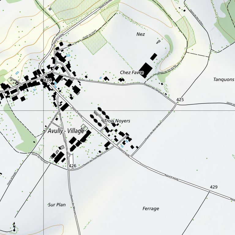
Route d'Avully runs from the northwest to the southeast, intersecting with several smaller paths. In the northwest, it passes through a cluster of buildings and greenery before moving southeast toward Ferrage. A network of paths branches off from Route d'Avully, including Chemin des Tanquons, which leads east toward Tanquons, and Chemin des Trois Noyers, which connects the central area to the south.

The village of Avully is concentrated in the western portion of the map, where a dense group of buildings is situated along Route d'Avully and Chemin des Meurons. This cluster extends southwards, with buildings scattered along Chemin des Meurons until it reaches a junction with Chemin des Trois Noyers.

In the center of the map, the area labeled Trois Noyers features a smaller, more dispersed group of buildings located where Route d'Avully and Chemin des Trois Noyers converge. To the north of this area lies Chez Favre, characterized by a few isolated buildings and a path called Chemin des Trois-Bois-les-Bois that winds northward toward Nez.

Further north, the landscape becomes more open with scattered green dots and a path called Chemin des Tacots leading toward the top edge of the map. In the southwest, the area labeled Sur Plan is mostly open land, with Chemin des Meurons running north-south and Chemin des Trois Noyers connecting to it from the east. The southeastern region, labeled Ferrage, is largely open, with Route d'Avully continuing its southeast trajectory. Various other paths, such as Chemin du Bois-de-Bais in the northeast and Chemin du Bois in the southwest, connect different parts of the rural landscape.
|
ch.swisstopo.pixelkarte-farbe
|
2.0
|
768
|
en
|
0.19434
|
2488815.08,1113470.65,2489815.08,1114470.65
|
{"sample_id": "tile_000095_02", "tile_id": "tile_000095", "bbox": "2488815.08,1113470.65,2489815.08,1114470.65", "layer": "ch.swisstopo.pixelkarte-farbe", "img_w": 768, "img_h": 768, "lang": "en", "scale": 2.0, "building_frac": 0.19434, "url": "https://wms.geo.admin.ch/?SERVICE=WMS&VERSION=1.3.0&REQUEST=GetMap&LAYERS=ch.swisstopo.pixelkarte-farbe&STYLES=&FORMAT=image%2Fpng&CRS=EPSG%3A2056&BBOX=2488815.08%2C1113470.65%2C2489815.08%2C1114470.65&WIDTH=768&HEIGHT=768&TRANSPARENT=false&LANG=en", "key": "000000114", "status": "success", "error_message": null, "width": 768, "height": 768, "original_width": 768, "original_height": 768, "exif": "{}", "sha256": "cc74b3ce3f35563a2542665bf9778ff242a34b27c5eb5bb4c26e6d16bc556d33", "shard": 0}
|
10
|
tile_000098_05
|
|
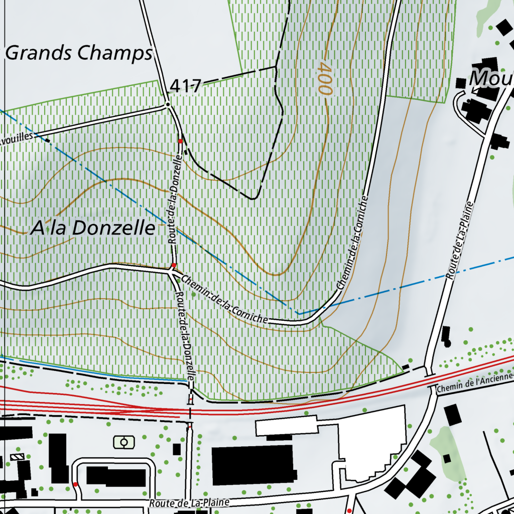
A network of roads and paths traverses a landscape of varying elevations, marked by contour lines. Route de la Donzelle runs vertically through the center of the area, intersecting with Chemin de la Corniche, which branches off to the east. Further east, Chemin de la Corniche runs roughly parallel to Route de la Plaine, which extends from the northeast down toward the south.

In the southern portion of the area, Route de la Donzelle meets a major east-west road marked by red lines, which is intersected by Chemin de l'Ancienne. South of this major road, Route de la Plaine continues southward, passing by several white building footprints and black structures.

The terrain is characterized by a mix of open spaces and forested or vegetated areas, indicated by green shading and patterns of small vertical lines. A blue dashed line cuts diagonally across the center from the northwest to the east. Several elevation markers are present, including "417" in the upper center and "400" further east. Buildings are clustered primarily in the northeast and southern sections of the map.
|
ch.swisstopo.pixelkarte-farbe
|
1.0
|
1024
|
en
|
0.03711
|
2488995.53,1115052.29,2489495.53,1115552.29
|
{"sample_id": "tile_000098_05", "tile_id": "tile_000098", "bbox": "2488995.53,1115052.29,2489495.53,1115552.29", "layer": "ch.swisstopo.pixelkarte-farbe", "img_w": 1024, "img_h": 1024, "lang": "en", "scale": 1.0, "building_frac": 0.03711, "url": "https://wms.geo.admin.ch/?SERVICE=WMS&VERSION=1.3.0&REQUEST=GetMap&LAYERS=ch.swisstopo.pixelkarte-farbe&STYLES=&FORMAT=image%2Fpng&CRS=EPSG%3A2056&BBOX=2488995.53%2C1115052.29%2C2489495.53%2C1115552.29&WIDTH=1024&HEIGHT=1024&TRANSPARENT=false&LANG=en", "key": "000000133", "status": "success", "error_message": null, "width": 1024, "height": 1024, "original_width": 1024, "original_height": 1024, "exif": "{}", "sha256": "66f3dab785265472b1444bcc8aef57c628522055b1818dcb6b5ea4f7f9a4842e", "shard": 0}
|